Squall lines are formed by the rapid ascent of warm, moist air over cooler air associated with advancing cold fronts. This creates atmospheric instability, leading to organized bands of thunderstorms that can extend for hundreds of miles. The dynamics of these systems are influenced by prevailing winds and temperature gradients. As weather patterns change, the intensity and movement of squall lines can be affected. Exploring further provides understanding into their impacts and forecasting techniques used by meteorologists.
Main Points
- Squall lines form when warm, moist air rises rapidly over a cold front, creating instability in the atmosphere conducive to thunderstorms.
- Cold fronts act as catalysts, forcing warm air upward, which organizes into elongated bands of thunderstorms known as squall lines.
- Prevailing winds steer squall lines, influencing their movement and direction as they interact with temperature gradients and topographical features.
- Advanced modeling techniques and data assimilation improve squall line predictions by integrating real-time observations and analyzing historical weather patterns.
- Squall lines can produce severe weather, including strong winds and heavy rainfall, necessitating timely warnings and community preparedness for safety.
Understanding Squall Lines: Definition and Characteristics
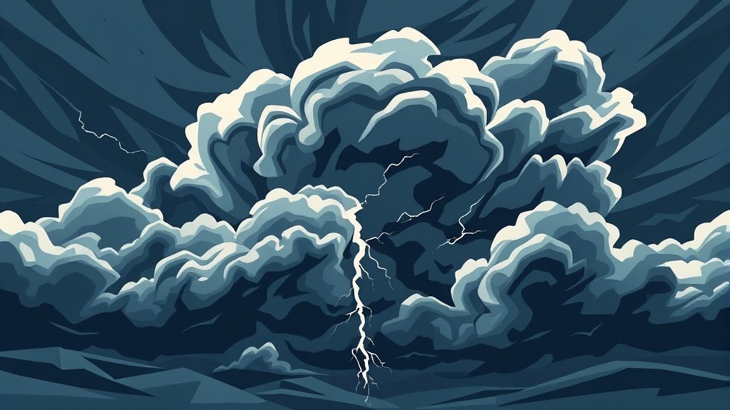
Although often overlooked in discussions of severe weather, squall lines play an essential role in shaping atmospheric conditions. These are elongated, narrow bands of thunderstorms that can produce severe weather phenomena, such as heavy rain, strong winds, and even tornadoes.
Typically associated with cold fronts, squall lines form when warm, moist air is lifted over cooler air, leading to the development of cumulonimbus clouds.
Characteristics of squall lines include their linear structure and the potential for organized, severe weather along their length. They can extend for hundreds of miles, often producing intense rainfall and gusty winds.
The leading edge of a squall line is marked by a sharp temperature change, and the storms within can exhibit persistent updrafts. Understanding these features is vital for meteorologists and weather enthusiasts alike, as squall lines can greatly impact local weather conditions and safety.
The Role of Cold Fronts in Squall Line Formation
Cold fronts play an important role in the formation of squall lines, acting as the catalyst that initiates the lifting of warm, moist air over cooler air masses. This vertical movement is essential for the development of severe weather conditions associated with squall lines.
The process can be outlined in three key steps:
- Advancement of Cold Air: As a cold front moves into an area, it forces the warmer air ahead of it to rise rapidly.
- Formation of Instability: This rapid lifting creates instability within the atmosphere, allowing for the potential for thunderstorms to develop.
- Development of Squall Lines: As the warm air continues to rise, it can organize into a line of thunderstorms, known as a squall line, which may produce intense winds, heavy rain, and severe weather.
Understanding the mechanics of cold fronts is vital for predicting squall line behavior and associated weather phenomena.
Warm, Moist Air: The Fuel for Squall Lines
Warm, moist air serves as an indispensable ingredient in the formation of squall lines. This air, typically originating from tropical or subtropical regions, is defined by high humidity and warmth. When this warm, moist air rises, it cools and condenses, forming clouds and precipitation. The process of condensation releases latent heat, which further energizes the surrounding atmosphere.
As the warm air ascends, it can create notable instability in the atmosphere, an important factor for squall line development. Moreover, the contrast between this warm, moist air and the cooler, denser air aloft amplifies the potential for severe weather phenomena.
The rising warm air interacts with existing weather systems, contributing to the formation of organized convective systems that can lead to squall lines. Consequently, the presence of warm, moist air plays a central role in fueling the dynamics of these intense weather events.
The Dynamics of Squall Line Movement
As squall lines develop, their movement is influenced by a combination of factors, including prevailing winds and the interaction with surrounding weather systems. Understanding these dynamics is vital for predicting their path and intensity.
The movement of squall lines can be attributed to three primary elements:
- Wind direction and speed: The prevailing winds can either steer the squall line or improve its forward momentum, affecting its trajectory.
- Temperature gradients: The differences in temperature across the squall line can create pressure systems that further influence its movement.
- Topographical features: Mountains and valleys can disrupt airflow, causing squall lines to shift direction or intensity as they traverse through varied terrains.
These factors work in conjunction to determine how squall lines propagate, making accurate forecasting a complex challenge for meteorologists.
Understanding these dynamics is essential for anticipating the potential impacts on affected regions.
Factors Influencing the Intensity of Squall Lines
The intensity of squall lines is shaped by several significant factors that interplay to determine their severity and impact. One primary factor is the amount of vertical wind shear, which refers to the change in wind speed and direction with altitude. Higher wind shear can improve the organization and longevity of squall lines.
Additionally, the availability of moisture in the atmosphere plays an essential role; a moist environment can fuel convection, leading to stronger thunderstorms within the squall line.
Temperature gradients also influence intensity, as warmer air at the surface can create instability, promoting vigorous updrafts. The presence of a cold front can act as a trigger, further intensifying the squall line as it forces warm, moist air to rise rapidly.
Finally, terrain and geographical features can modify squall line behavior, impacting both development and intensity as they interact with localized climatic conditions.
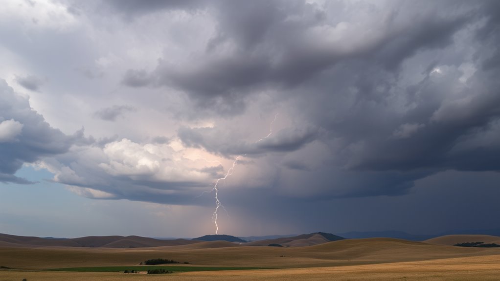
Squall Lines and Severe Weather: Impacts and Risks
Squall lines, often associated with severe weather phenomena, can produce a range of hazardous impacts that pose substantial risks to life and property.
These organized bands of thunderstorms are capable of generating intense conditions, including:
- Severe Winds: Squall lines can produce straight-line winds exceeding 60 mph, leading to downed trees, power outages, and structural damages.
- Heavy Rainfall: The intense precipitation associated with squall lines can cause flash flooding, overwhelming drainage systems and endangering lives.
- Hail: Some squall lines generate large hailstones, which can damage vehicles, crops, and roofs, resulting in considerable economic loss.
Due to these potential hazards, communities situated in the path of approaching squall lines are urged to stay informed and take necessary precautions.
Understanding the impacts and risks associated with these weather phenomena is essential for effective preparedness and response strategies.
Monitoring and Predicting Squall Lines in Meteorology
Monitoring and predicting squall lines are critical components of meteorology that rely heavily on advanced technologies.
Weather radar plays a key role in detecting the formation and movement of these lines, providing real-time data to forecasters.
Additionally, advanced modeling techniques improve the accuracy of predictions, allowing meteorologists to anticipate severe weather events associated with squall lines.
Weather Radar Utilization
Weather radar serves as an essential tool in meteorology, particularly for monitoring and predicting the formation and movement of squall lines. By utilizing radar technology, meteorologists can identify crucial features associated with these severe weather phenomena.
Key aspects of weather radar utilization include:
- Detection of Precipitation: Radar systems enable the identification of rain and storm cells, allowing for early warnings of squall lines.
- Velocity Measurements: Doppler radar measures wind speed and direction, providing understanding into the dynamics of squall line movement.
- Intensity Mapping: Radar can assess the intensity of storms, helping predict potential hazards associated with squall lines, such as strong winds or hail.
Through these capabilities, weather radar plays an essential role in enhancing meteorological forecasting and public safety.
Advanced Modeling Techniques
Utilizing advanced modeling techniques has revolutionized the approach to predicting squall lines in meteorology. These techniques incorporate high-resolution numerical weather prediction models that simulate atmospheric conditions with exceptional accuracy.
By utilizing data assimilation, meteorologists can integrate real-time observations into these models, boosting their ability to forecast squall line development and movement. Additionally, machine learning algorithms are increasingly being employed to analyze historical weather patterns, allowing for the identification of specific conditions that lead to squall line formation.
This integration of technology provides more reliable predictions, enabling quicker responses to severe weather threats. Consequently, advanced modeling techniques not only improve understanding of squall lines but also promote public safety through timely warnings and preparedness measures.
Common Questions
Can Squall Lines Form in Tropical Regions?
Squall lines can indeed form in tropical regions. These weather phenomena often arise in response to specific atmospheric conditions, including moisture, instability, and wind shear, which are prevalent in tropical climates, leading to intense thunderstorms.
How Do Squall Lines Differ From Regular Thunderstorms?
Squall lines are organized clusters of thunderstorms defined by strong winds and heavy precipitation, differing from regular thunderstorms, which can be isolated and less intense. Squall lines often produce severe weather over larger areas.
What Safety Precautions Should Be Taken During a Squall Line?
During a squall line, individuals should seek shelter indoors, avoid windows, secure outdoor objects, and stay informed through weather updates. Additionally, having an emergency kit ready can improve safety in unpredictable conditions associated with severe weather.
Are Squall Lines More Common in Certain Seasons?
Squall lines are indeed more prevalent during specific seasons, particularly in spring and summer. These periods enhance the necessary atmospheric conditions, such as increased moisture and instability, which encourage the development of these intense weather phenomena.
How Do Squall Lines Affect Local Ecosystems?
Squall lines greatly impact local ecosystems by causing rapid changes in temperature, humidity, and wind patterns. These alterations can influence plant growth, animal behavior, and water availability, ultimately reshaping habitats and community dynamics within affected areas.