
Convective instability is essential in severe squall events, as it causes warm, less dense air parcels to rise rapidly. This process leads to the development of cumulonimbus clouds and intense thunderstorms. Key factors such as high humidity, temperature contrasts, and wind shear contribute to this instability, promoting storm organization and prolonging intensity. Understanding these dynamics is imperative for predicting severe weather and minimizing risks associated with squall events. Further exploration reveals deeper understandings into these important atmospheric interactions.
Main Points
- Convective instability arises from warm, buoyant air rising, contributing to the development of cumulonimbus clouds during severe squall events.
- High humidity levels provide necessary moisture, enhancing the convective instability essential for thunderstorm formation.
- Temperature contrasts between surface and aloft air create instability, leading to rapid vertical motion and severe weather phenomena.
- Effective wind shear promotes storm organization and intensity, allowing for prolonged updrafts and reducing storm decay.
- Accurate forecasting of convective instability is crucial, as severe squalls can develop and dissipate rapidly, complicating warning issuance.
Understanding Convective Instability
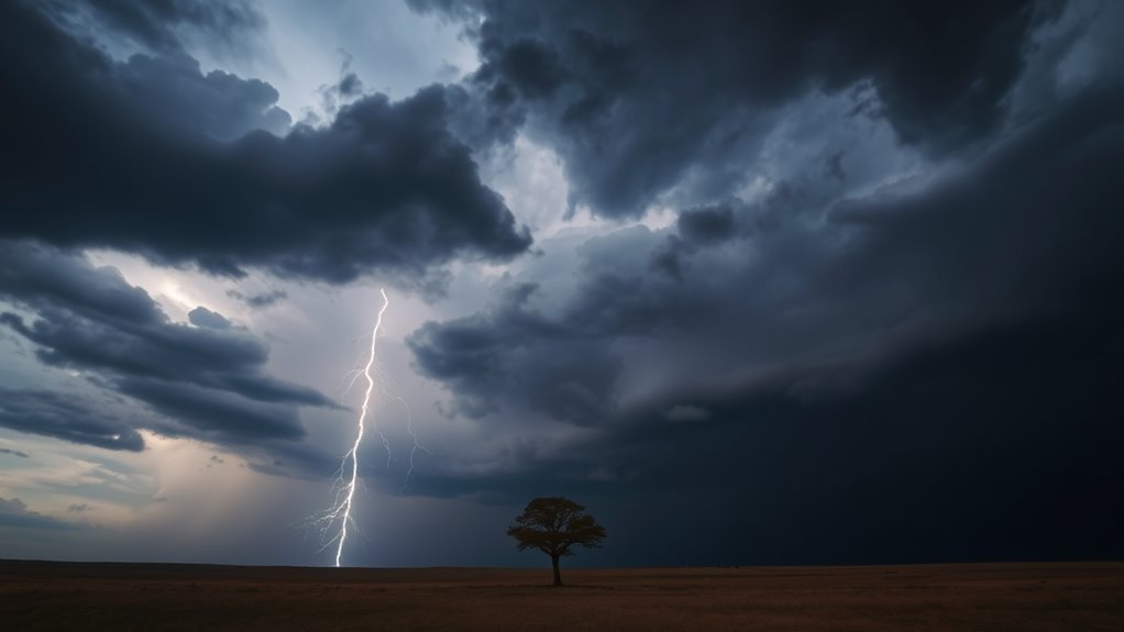
Convective instability is a critical factor in the formation of severe weather phenomena, particularly squall events. It refers to the tendency of an air parcel to rise when it is warmer and less dense than its surrounding environment.
When sufficient moisture and heat are present, the air becomes buoyant, leading to the development of cumulonimbus clouds and potential storm systems. This instability is often driven by surface heating during the day or the presence of warm, moist air at low levels, which contrasts with cooler, drier air aloft.
As the warm air ascends, it can cool and condense, releasing latent heat that further promotes upward motion. The resulting vertical development of clouds can lead to intense precipitation, strong winds, and even lightning.
Understanding this process is essential for meteorologists, as it helps in predicting severe weather patterns and the potential for squall lines to form.
The Formation of Severe Squall Events
The formation of severe squall events is contingent upon specific atmospheric conditions that encourage instability.
High levels of humidity play a crucial role, as they provide the necessary moisture for intense convective processes.
Additionally, wind shear greatly influences the development and strength of these squall lines, creating a dynamic environment conducive to severe weather.
Atmospheric Conditions Required
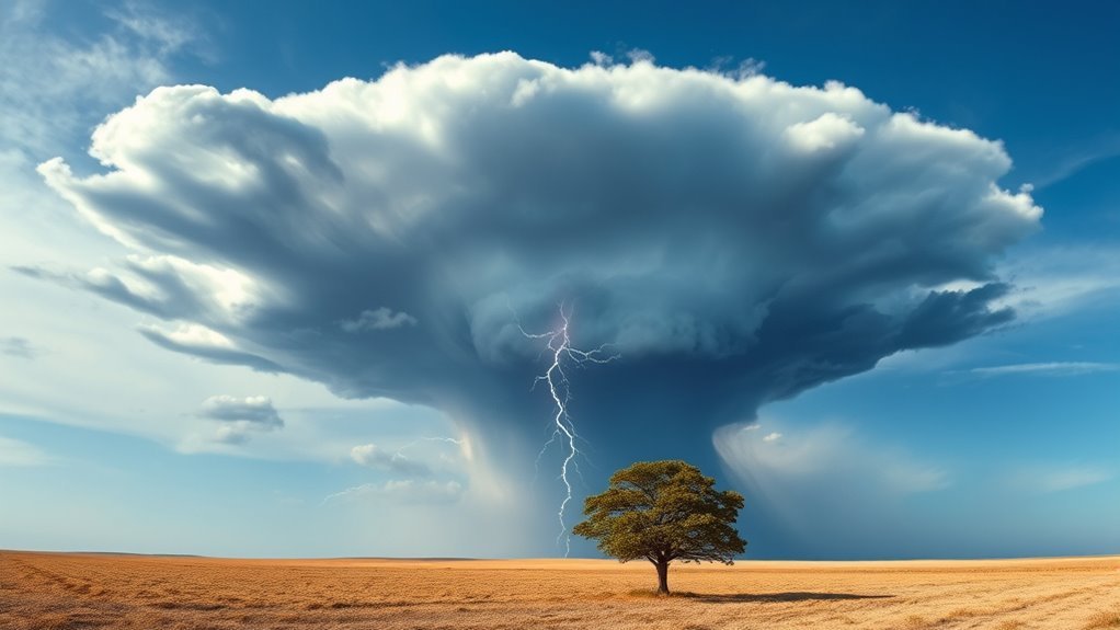
While various atmospheric conditions contribute to the formation of severe squall events, the presence of remarkable temperature contrasts and moisture levels plays an essential role. A considerable temperature gradient, typically between warm, moist air at the surface and cooler, drier air aloft, creates an unstable atmosphere conducive to convective activity. This instability encourages the rapid upward movement of air, leading to the development of cumulonimbus clouds.
Additionally, the wind shear, which is the variation in wind speed and direction with altitude, can improve the organization and longevity of these storm systems. When combined, these factors create an environment ripe for severe squall events, resulting in strong winds, heavy precipitation, and potential severe weather phenomena such as thunderstorms and tornadoes.
Role of Humidity
Humidity serves as a crucial component in the formation of severe squall events. Raised moisture levels in the atmosphere improve the potential for convective instability, which is essential for the development of intense thunderstorms.
When warm, moist air rises and interacts with cooler surrounding air, it can lead to rapid condensation and the release of latent heat. This process fuels storm development, contributing to the intensity and longevity of squall lines.
High humidity also promotes the growth of cumulonimbus clouds, which are fundamental to severe squall events. Additionally, increased moisture content in the air supports the generation of heavy precipitation, lightning, and strong winds, all characteristic features of severe storms.
Consequently, humidity plays a crucial role in the dynamics of squall formation.
Wind Shear Influence
Effective wind shear is a key factor in the formation of severe squall events, as it creates the necessary conditions for storm organization and development.
Wind shear, defined as the change in wind speed and direction with height, can improve the vertical development of thunderstorms. When lower-level winds are stronger than those aloft, they can tilt the storm's updraft, allowing it to maintain intensity and prolong its lifecycle.
This tilting helps to separate the updraft from the downdraft, reducing the likelihood of storm decay. Additionally, effective wind shear can lead to organized storm structures, such as supercells, which are often responsible for severe weather phenomena.
Understanding the influence of wind shear is essential for predicting and evaluating the severity of squall events.
Key Indicators of Convective Instability

Key indicators of convective instability include temperature and humidity profiles, as well as wind shear characteristics.
These factors play a critical role in determining the potential for severe squall events.
Understanding their interplay can improve predictive capabilities for atmospheric disturbances.
Temperature and Humidity Profiles
Temperature and humidity profiles serve as critical indicators of convective instability within the atmosphere.
These profiles reveal the vertical distribution of temperature and moisture, which greatly influence the potential for convection. A steep temperature gradient, where warm air resides beneath cooler air, creates an unstable environment conducive to upward motion.
Additionally, high humidity levels in the lower troposphere can improve the buoyancy of rising air parcels, further promoting convective activity.
The combination of warm, moist air at the surface and cooler, drier air aloft cultivates conditions ripe for severe weather phenomena.
Accurate analysis of these profiles enables meteorologists to predict the likelihood and intensity of convective storms, making them essential in forecasting severe squall events.
Wind Shear Characteristics
Wind shear characteristics play an essential role in identifying convective instability within the atmosphere.
Wind shear, defined as the change in wind speed and direction with altitude, can notably impact the development and organization of convective systems. Strong vertical wind shear often improves the tilting of storm updrafts, allowing for greater longevity and intensity of severe thunderstorms.
Additionally, the presence of directional wind shear can lead to rotating updrafts, which are critical for the formation of supercells associated with severe squall events.
The magnitude and profile of wind shear can serve as key indicators, helping meteorologists assess the potential for severe weather, including tornadoes and damaging winds, thereby underscoring its importance in forecasting convective instability.
The Dynamics of Storm Development
Storm development is a complicated process influenced by various atmospheric conditions. Several key factors contribute to the formation of severe storms, each playing a significant role in determining the intensity and longevity of the event.
- Moisture Availability: Sufficient moisture in the lower atmosphere is essential for cloud formation and precipitation.
- Temperature Gradients: The interaction between warm and cold air masses creates instability, which can lead to rapid storm development.
- Lift Mechanisms: Various lifting mechanisms, such as fronts or terrain, can initiate convection, further enhancing storm formation.
Collectively, these elements interact dynamically, resulting in the development of severe weather systems.
Understanding these processes is important for meteorologists as they work to predict and mitigate the impacts of severe squall events. The complex interplay of these factors ultimately dictates the nature and severity of the storms that may ensue.
Impacts of Convective Instability on Weather Conditions
Convective instability serves as an essential factor in shaping weather conditions, particularly during severe squall events. It improves vertical motion within the atmosphere, leading to the rapid development of thunderstorms. When warm, moist air rises, it encounters cooler air aloft, causing the formation of cumulonimbus clouds that can produce intense precipitation, strong winds, and lightning.
This instability can also contribute to the development of downdrafts, resulting in damaging gust fronts that further exacerbate squall conditions.
Additionally, convective instability is linked to the organization of storm systems, affecting their longevity and intensity. It can lead to the formation of organized convection, such as squall lines, which can propagate over long distances, causing widespread severe weather.
The impacts of convective instability therefore extend beyond localized events, influencing broader weather patterns and presenting considerable risks to affected areas. Understanding these dynamics is essential for effective weather monitoring and response strategies.
Forecasting Challenges Associated With Severe Squalls
Forecasting severe squalls presents considerable challenges due to their complex and dynamic nature. The rapid development and dissipation of these weather events often elude standard predictive models. Additionally, the interplay of various atmospheric conditions complicates accurate forecasting.
Key challenges include:
- Short-lived phenomena: Severe squalls can form and dissipate within minutes, making timely predictions difficult.
- Localized impacts: The intensity and effects of squalls can vary dramatically over short distances, which complicates the issuance of warnings.
- Data limitations: Inadequate observational data in certain regions can hinder model accuracy, leading to potential underestimations of severity.
These factors necessitate the continuous refinement of forecasting techniques and the development of more sophisticated models to improve predictive capabilities.
Addressing these challenges is essential for enhancing the accuracy and reliability of squall forecasts.
Enhancing Safety Through Improved Predictions
Improved predictions of severe squalls can greatly improve safety measures for communities and industries affected by these rapid weather events. Advanced meteorological models that incorporate data on convective instability boost the accuracy of forecasts. By pinpointing the likelihood and timing of squall occurrences, these predictions enable timely alerts, allowing residents to take necessary precautions.
Moreover, industries such as agriculture and transportation can adjust operations based on forecasted squall activity, minimizing potential damage and disruptions. Enhanced prediction capabilities also promote better resource allocation for emergency services, ensuring that responders are prepared for severe conditions.
The integration of real-time data and machine learning algorithms further refines predictive models, enabling meteorologists to assess evolving atmospheric conditions. As a result, communities can develop more effective preparedness strategies, in the end saving lives and reducing economic losses associated with severe squall events.
Common Questions
How Does Climate Change Affect Convective Instability Patterns?
Climate change alters atmospheric conditions, increasing temperatures and moisture levels. This results in improved convective instability patterns, potentially leading to more intense storms and unpredictable weather events, thereby impacting regional climate dynamics and weather forecasting.
Can Convective Instability Lead to Tornado Formation?
Convective instability can create conditions favorable for tornado formation. When warm, moist air rises rapidly, it may interact with cooler air above, potentially leading to the development of severe storms capable of producing tornadoes under specific circumstances.
What Role Does Topography Play in Convective Instability?
Topography influences convective instability by altering local wind patterns and moisture distribution. Mountains can improve lift, creating localized areas of instability, while valleys may inhibit convection, thereby greatly impacting weather patterns and storm development.
Are There Specific Seasons More Prone to Convective Instability?
The question of seasonal susceptibility to convective instability reveals that spring and summer typically exhibit heightened instability due to warmer temperatures and increased moisture, contributing to the development of severe weather conditions.
How Do Urban Areas Influence Convective Instability?
Urban areas influence convective instability by altering local temperature and moisture levels through heat islands and land use changes. These modifications can improve atmospheric dynamics, potentially increasing the frequency and intensity of convective weather phenomena.