
Squalls form due to specific atmospheric conditions and wind behavior that create instability. Warm, moist air rises rapidly as cold fronts and cooler air aloft interact, leading to convection and cloud formation. Sharp temperature gradients improve this process, promoting rapid ascension and precipitation. Wind behavior, such as convergence and changes in speed or direction, can intensify these conditions, resulting in hazardous weather phenomena. Exploring these dynamics further reveals deeper understandings into squall formation and consequences.
Main Points
- Squalls form when warm, moist air near the surface rises rapidly, meeting cooler, drier air aloft, creating instability.
- Wind shear and changes in wind speed and direction can trigger sudden shifts in weather, leading to squall development.
- Convergence zones, where winds from different directions meet, enhance instability and facilitate the formation of squall lines.
- Strong updrafts caused by localized heating promote convection, leading to rapid cloud formation and intense precipitation.
- Temperature gradients and high humidity levels contribute to the rapid ascension of warm air, increasing the likelihood of squalls.
Understanding Squalls: Definition and Characteristics
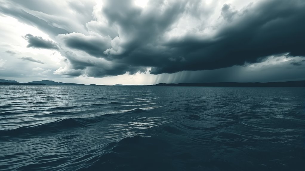
Squalls are sudden and intense bursts of wind, often accompanied by rain or thunderstorms, that can greatly impact weather conditions. Typically occurring in frontal zones, they can manifest rapidly, sometimes within minutes, creating hazardous situations for those caught in their path.
Squalls are marked by a sharp increase in wind speed, usually exceeding 20 knots, and can result in gusts that are notably stronger. The accompanying precipitation can range from light rain to torrential downpours, which may reduce visibility and create slippery surfaces.
These events can occur in various environments, including coastal areas and inland regions. While squalls are often short-lived, their intensity can lead to severe weather warnings and necessitate caution for mariners and outdoor enthusiasts.
Understanding the defining traits of squalls is essential for predicting their occurrence and evaluating potential impacts on safety and property.
The Role of Atmospheric Instability in Squall Formation

Atmospheric instability plays an essential role in the formation of squalls, as it creates the conditions necessary for rapid and intense weather changes. This instability occurs when warm, moist air is present near the surface, while cooler, drier air resides aloft.
Such a scenario promotes the development of convection, where the warm air rises, cools, and condenses, leading to cloud formation and precipitation. As the warm air ascends, it can create strong updrafts, which, when combined with wind shear, contribute to the organization of squall lines.
These lines can produce severe weather phenomena, including heavy rain, lightning, and strong winds. Moreover, atmospheric instability is often improved by localized heating from the sun or the presence of a front, which can trigger the rapid development of squalls.
Understanding these dynamics is essential for predicting squall events and their potential impact on the environment and human activities.
Temperature Gradients and Their Impact on Squalls
Temperature gradients play a critical role in the formation of squalls by influencing the behavior of air masses.
The interaction between warm air ascension and cold fronts can create considerable instability, leading to the rapid development of squall conditions.
Understanding these dynamics is essential for predicting the intensity and duration of squalls.
Warm Air Ascension
Warm air ascension plays an essential role in the formation of squalls, greatly influenced by temperature gradients within the atmosphere.
When warm air rises, it cools adiabatically, leading to condensation and cloud formation. This process is often initiated when warm, less dense air encounters cooler air masses, creating instability.
The temperature difference between these air masses is vital; a steeper gradient increases the likelihood of rapid ascension. As the warm air rises, it can generate strong updrafts, which may lead to the development of thunderstorms associated with squalls.
These updrafts contribute to the intensity of precipitation and wind gusts experienced during a squall, highlighting the critical link between warm air ascension and squall dynamics.
Cold Front Interaction
When a cold front advances into an area occupied by warm air, the resulting temperature gradient can considerably influence the formation and severity of squalls. The sharp contrast between the cooler, denser air and the warmer, lighter air leads to rapid vertical movement, improving the likelihood of intense precipitation and strong winds.
This interaction creates a conducive environment for squalls to develop, defined by their sudden onset and brief duration.
- Cold fronts typically move faster than warm fronts, intensifying the friction at the boundary.
- The steep temperature gradient can lead to powerful updrafts, further fueling squall formation.
- Improved wind shear associated with cold fronts can contribute to the organization of squall lines, increasing their severity.
Instability Induction Factors
The interaction between cold and warm air masses creates considerable temperature gradients that play an important role in the induction of atmospheric instability.
When warm air rises over a denser cold air mass, it can lead to rapid cooling and condensation, forming clouds. This process of lifting warm air results in a decrease in pressure and allows for further air to rise, increasing instability within the atmosphere.
Additionally, steep temperature gradients can improve wind shear, contributing to the development of squalls.
As these contrasting air masses interact, the resulting turbulence can instigate sudden shifts in wind direction and intensity, finally culminating in the formation of intense weather phenomena such as squalls.
Understanding these dynamics is vital for predicting and responding to severe weather events.
Moisture Content and Its Influence on Weather Patterns
Moisture content plays a critical role in shaping weather patterns, particularly in relation to humidity and cloud formation.
Higher humidity levels can lead to increased cloud development, which directly influences precipitation and atmospheric stability.
Understanding these dynamics is essential for comprehending how squalls and other weather phenomena occur.
Humidity and Cloud Formation
Humidity plays an essential role in cloud formation, as it directly influences the amount of water vapor present in the atmosphere. When humidity levels rise, the air becomes saturated, leading to condensation. This process is fundamental for the development of clouds, which are formed from tiny water droplets or ice crystals.
- High humidity often signals the potential for storm development.
- Low humidity can result in clear skies and minimal cloud formation.
- Variations in humidity can lead to different types of clouds, such as cumulus or stratus.
Understanding humidity's impact helps meteorologists predict weather patterns and the likelihood of squalls.
Therefore, recognizing the significance of moisture content is critical for grasping atmospheric dynamics.
Precipitation and Atmospheric Stability
Precipitation is a key indicator of atmospheric stability, as it reflects the balance between moisture content and the vertical movements of air in the atmosphere. High moisture levels can lead to increased instability, encouraging the development of convective currents that facilitate the upward movement of warm air.
This dynamic can result in notable precipitation events, such as thunderstorms or squalls, as the rising air cools and condenses moisture into droplets. Conversely, low moisture content tends to stabilize the atmosphere, suppressing vertical movement and resulting in drier conditions.
Understanding these relationships helps meteorologists predict weather patterns and the likelihood of precipitation, essential for planning in various sectors, including agriculture and disaster management.
Atmospheric stability, consequently, plays an important role in shaping weather dynamics.
Wind Behavior: How It Triggers Squalls

While various atmospheric conditions contribute to the development of squalls, wind behavior plays a critical role in triggering these sudden storms. The interaction of winds at different altitudes can lead to notable changes in temperature and moisture levels, creating the ideal environment for squall formation.
When strong winds collide with local air masses, they can generate turbulence and lift, pushing warm, moist air upward and causing rapid cooling and condensation.
- Wind Shear: Changes in wind speed and direction can intensify storm development.
- Convergence Zones: Areas where winds from different directions meet can encourage instability.
- Topographical Influences: Mountains or valleys can channel winds, enhancing their strength and impact.
Understanding these wind dynamics is essential for predicting squalls and mitigating their potential hazards.
The Relationship Between Pressure Variations and Squalls
Pressure variations play an essential role in the formation of squalls, as shifts in atmospheric pressure can create the instability necessary for these intense weather events. When a low-pressure system moves into an area, it often causes a rapid increase in wind speed and direction changes, contributing to turbulent conditions. This instability can lead to the development of squalls, defined by sudden, intense bursts of wind and precipitation.
Conversely, high-pressure systems can suppress squall formation by stabilizing the atmosphere. Nevertheless, the change between these pressure systems can create notable gradients, leading to the onset of squalls.
Additionally, when warm, moist air rises rapidly due to pressure differences, it can condense and produce heavy rainfall associated with squalls. Understanding the relationship between pressure variations and squalls is vital for meteorologists to predict these sudden weather phenomena and their potential impact on the environment.
Real-World Examples of Squalls and Their Effects
Squalls can have notable impacts on various regions, as evidenced by numerous actual occurrences. These weather phenomena are notorious for their sudden onset and can cause substantial disruptions in daily life.
Notable examples illustrate the varied effects of squalls across different environments:
- Maritime Disruptions: Squalls can create hazardous conditions for ships, leading to capsizing and loss of cargo.
- Urban Flooding: Sudden downpours associated with squalls can overwhelm drainage systems, resulting in flash flooding in metropolitan areas.
- Agricultural Damage: Strong winds and heavy rain can destroy crops, impacting local economies and food supply.
In the United States, the Great Plains often experience squall lines during spring storms, leading to severe thunderstorms.
Similarly, coastal regions may witness squalls that disrupt fishing operations and pose risks to small vessels.
These occurrences highlight the need for effective forecasting and preparedness strategies to mitigate squall-related impacts.
Common Questions
How Do Squalls Differ From Thunderstorms?
Squalls and thunderstorms differ primarily in intensity and duration. Squalls are brief, sharp increases in wind and precipitation, while thunderstorms are defined by organized convection, producing lightning, thunder, and often lasting longer with more severe weather conditions.
Can Squalls Occur in Winter Conditions?
Squalls can indeed occur during winter conditions, marked by sudden, intense bursts of wind and precipitation. These phenomena often lead to reduced visibility and rapidly changing weather, impacting travel and outdoor activities considerably.
What Safety Measures Should Be Taken During a Squall?
During a squall, individuals should seek shelter indoors, secure outdoor objects, avoid unnecessary travel, and monitor weather updates. Staying away from windows and using flashlights for visibility can improve safety during turbulent conditions.
How Long Do Squalls Typically Last?
Squalls typically last from a few minutes to half an hour, depending on the intensity and atmospheric conditions. Their rapid onset and brief duration can lead to sudden changes in weather, requiring caution.
Are Squalls Predictable Using Weather Forecasts?
Squalls are somewhat predictable using weather forecasts, as meteorologists analyze atmospheric data and patterns. Nevertheless, the rapid nature of squall development can make precise timing and intensity challenging, leading to occasional inaccuracies in predictions.